![]()
![]()
![]()
![]()
![]()
![]()
![]()
|
|
|
|
|
|
|
|
OTHER IMAGES
In addition to the new bathymetric maps and 3D images that have been generated with the newly compiled bathymetric, shoreline and topographic data set, a number of other figures have also been added to this CD-Rom. These are either figures that have been generated from the same new data set, or figures that have been added because they bring additional information that may be of help when using the new bathymetry maps.
These images are in .jpg or .gif image file formats and they can thus be handled by most software applications. By clicking on the links, the (larger) files will be opened in a separate browser window.
|
|
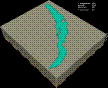
ANIMATED
3D IMAGE OF LAKE
BAIKAL. This animation illustrates how Lake Baikal would look in case the water would be removed step by step, in steps of 100 m. It also visualises from which water depth the three major basins would become totally separated. image on larger scale in .gif format |
|
|
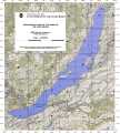
TOPOGRAPHIC
MAP
OF THE LAKE BAIKAL REGION. This map is a topographic contour map in ARC System projection (WGS 1984 Ellipsoid), at a natural scale of 1:1,000,000. The original data are a product of the National Imagery and Mapping Agency in compressed ARC Digitized Raster Graphics format. topographic
map in .pdf format |
|
|
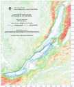
TOPOGRAPHIC
CONTOUR MAP
OF THE LAKE BAIKAL REGION. This map is a colored contour map in Mercator projection (WGS 1984 Ellipsoid), at a natural scale of 1:500,000 (true scale at 53°00' N). Contour interval is 100 m. Contours in the lake are in metres below lake level; contours on land are in metres above sea level.
topographic contour map in .pdf format |
|
|
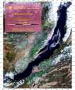
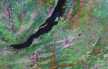
SATELLITE
MAP OF THE LAKE BAIKAL REGION. This map is a mosaic composition of Landsat and MODIS satellite images from NASA in UTM projection (WGS 1984 Ellipsoid), at a scale of 1:500,000.
|
|
|
SATELLITE
IMAGE OF THE LAKE BAIKAL REGION. This image is a Landsat satellite image mosaic of the Lake Baikal region. satellite image mosaic in .jpg format |
©
the INTAS Project 99-1669 Team, October 2002.
For more information contact: Marc.DeBatist@rug.ac.be