![]()
![]()
![]()
![]()
![]()
![]()
![]()
|
|
|
|
|
|
|
|
MAPS
All maps on this CD-Rom exist in two formats:
By clicking on the links, the files will be opened in a separate browser window.
|
|
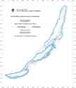
BATHYMETRIC
CONTOUR MAP OF LAKE BAIKAL. This map is a coloured contour map in Mercator projection (WGS 1984 Ellipsoid), at a natural scale of 1:500,000 (true scale at 53°00' N). Contour interval is 50 m; thicker lines every 250 m. bathymetric
contour map in .pdf format |
|
|
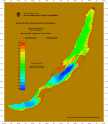
BATHYMETRIC
COLOR MAP OF LAKE BAIKAL. This map is a depth-interval colour-coded map in Mercator projection (WGS 1984 Ellipsoid), at a natural scale of 1:500,000 (true scale at 53°00' N). Colour interval is 100 m. bathymetric
colour map in .pdf format |
|
|
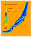
BATHYMETRIC
COLOUR MAP OF LAKE BAIKAL. This map is a depth-interval colour-coded map in Mercator projection (WGS 1984 Ellipsoid), at a natural scale of 1:500,000 (true scale at 53°00' N). Colour interval is 100 m. bathymetric
colour map in .pdf format |
|
|
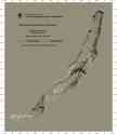
SHADED-RELIEF
MAP
OF LAKE BAIKAL. This map is a grey shaded-relief map in Mercator projection (WGS 1984 Ellipsoid). shaded-relief
map in .pdf format |
|
|
COLOUR-SHADED-RELIEF
MAP
OF LAKE BAIKAL. This map is a colour-shaded-relief map in Mercator projection (WGS 1984 Ellipsoid). Colour scale is the same as the depth-interval colour-coded map; colour interval is 100 m. colour-shaded-relief
map in .pdf format |
|
|
SLOPE
MAP
OF LAKE BAIKAL. This map is a coloured slope gradient map in Mercator projection (WGS 1984 Ellipsoid), at a natural scale of 1:500,000 (true scale at 53°00' N). Colour interval is 1° for slopes between 0 and 10°, and 2° for slopes between 10 and 40°. |
©
the INTAS Project 99-1669 Team, October 2002.
For more information contact: Marc.DeBatist@rug.ac.be