


Expedition on R/V Akademik Koptyug on June 5-18, 2026
Purpose of the expedition: To assess the quality of surface, near-bottom, and interstitial waters in the coastal zone, and to study species diversity, taxocenoses, and community structures at sampling sites affected by negative environmental processes.
Expedition objectives:
- Collection of material for establishing long-term time series on the seasonal and interannual dynamics of biomass and species composition of filamentous macroalgae (including cyanobacteria) in the shallow-water zone of Lake Baikal;
- Collection of benthic samples for taxonomic analysis of harpacticoid copepods, ostracods, turbellarians, and microturbellarians inhabiting the littoral and profundal zones of Lake Baikal;
- Collection of samples for assessing the condition of phytoplankton in the littoral and pelagic zones of Lake Baikal;
- Collection of data on coastal detritus accumulations (CDA) in areas of mass deposition, as an indirect indicator of elevated productivity in the littoral zone of Lake Baikal;
- Collection of microbiological samples for water quality assessment in the coastal zone of Lake Baikal; sampling of interstitial waters for the presence of sanitary-indicator microorganisms; sanitary-microbiological sampling in selected tributaries; collection of additional coastal and interstitial water samples at sites of coastal detritus accumulations for the detection of secondary pollution;
- Collection of data on the spatial distribution and temporal dynamics of hydrochemical parameters in interstitial waters and in the coastal splash zone of Lake Baikal; hydrochemical sampling in selected tributaries along the eastern shore; collection of additional coastal and interstitial water samples at sites of coastal detritus accumulations for the detection of secondary pollution.
- Collection of microbiological samples for determining the abundance and diversity of ammonium-oxidizing bacteria in the littoral zone of Lake Baikal.
Expedition team: : Dr. Sci. (Biol.) O.A. Timoshkin (head of the team), Cand. Sci. (Biol.) V.V. Malnik (deputy head of the team), Leading Engineer M.I. Gula, Chief Specialist A.E. Poberezhnaya, Postgraduate Student R.S. Krivorotkin, Postgraduate Student T.M. Alekseeva, Researcher G.V. Kan, Cand. Sci. (Biol.), Head of the Department of Zoology A.G. Porfiryev, and Assistant D.V. Lapteva (Kazan (Volga Region) Federal University), as well as V.D. Kiskina, a 1st‑year undergraduate student of the Department of Biology, Institute of Biological Sciences, Irkutsk State University (ISU).
List of main sections and responsible staff: Hydrochemical studies (responsible executor: I.V. Tomberg), Phytoplankton (responsible executor: N.A. Bondarenko; responsible for sampling – A.E. Poberezhnaya), Phytobenthos (responsible executors: O.A. Timoshkin, R.A. Yurgin, M.I. Gula), Shoreline accumulations of detritus (responsible executors: R.S. Krivorotkin, T.M. Alekseeva, A.V. Nepokrytykh, O.A. Timoshkin), Zoobenthos (responsible executors: R.S. Krivorotkin, T.M. Alekseeva); Bacterial and pelagic microorganisms (responsible executor: V.V. Malnik).
Names and registration numbers of the research themes included in the R&D Plan for the implementation of which the expedition was carried out:
“Impact of negative ecological processes in the coastal zone of Lake Baikal on the quality of interstitial, near-bottom, and shoreline water, and consequently on the diversity of species, taxocenoses, and communities”, FWSR-2026-0016, 1025032600024-3-1.5.13.
Expedition route map:
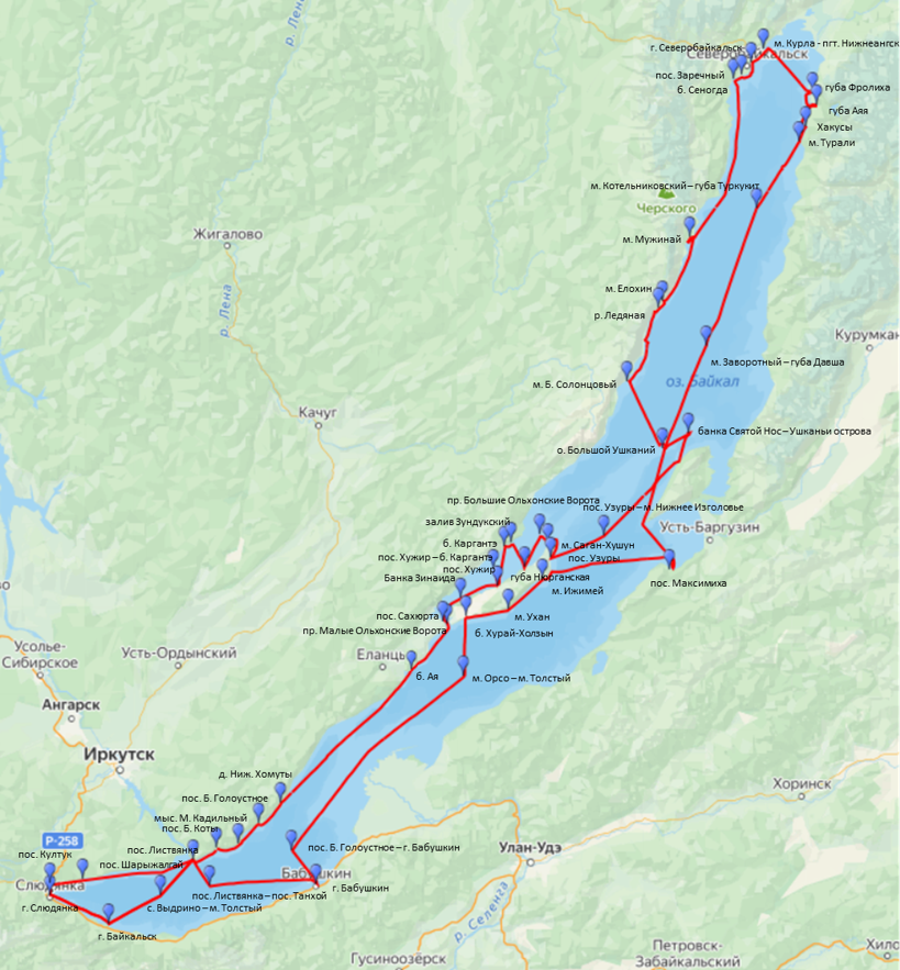
- Listvyanka settlement: N 51°50'43.4'' E 104°52'30.9''
- Bolshye Koty settlement: N 51°54'01.6" E 105°03'52.2''
- Bolshoe Goloustnoe settlement: N 52°01'36.8" E 105°24'14.4"
- Maly Kadilny cape: N51°55'18.1920" E105°14'25.584"
- Aya bay: N 52°47'14.4" E 106°36'12.5
- Malye Olkhonskye Vorota strait: N 53°00'3.9'' E 106°55'13.9''
- Sakhyurta settlement: N 53°01'05.8" E 106°53'13.6"
- Maloye More, Zinaida Bank, east of Ogoy Island: N53°07'59.4408", E107°01'28.8804"
- Transect Khuzhir – Kargante Bay: N53°16'02.1" E107°17'40.02"
- Khuzhir settlement: N 53°11'32.5" E 107°19'46.8"
- Kargante Bay: N 53°22'57.6" E 107°23'05.7"
- Maloye More, Zunduk Bay: N53°23'55.9661", E107°26'25.6860"
- Nyurgan Bay: N 53°17’10.8” E 107°32’50.4”
- Sagan-Khushun cape, Tri Brata rock: N53°23'38.22", E107°44'01.914"
- Bolshye Olkhonskye Vorota strait: N 53°26'27.7" E 107°39'30.4"
- Uzury settlement: N 53°19'34.6" E 107°45'35.9"
- Bank between the northern cape of Svyatoy Nos and the Ushkany Islands: N53°55'18.2418", E108°52'06.0516"
- Transect Uzury – Cape Nizhneye Izgolovye (Svyatoy Nos peninsula): N53°25'56.9400" E108°11'12.72"
- Bolshoy Ushkany Island: N 53°51'06.3" E 108°39'18.2"
- Bolshoi Solontsovyi cape: N 54°10'14.3" E 108°22'13.1"
- Elokhin cape: N 54°32'36.8" E 108°39'34.7"
- Cape Muzhinay – Bolshaya Kosa Bay: N 54°50’48.5” E 108°52’42.2”
- 300 m south of the Ledyanaya River: 54.517196, 108.624315"
- Senogda bay: N 55°34'37.0" E 109°13'34.7"
- Zarechny settlement: N 55°35'40.1" E 109°17'50.9"
- Severobaykalsk, opposite Tyya River mouth: N55°35'46.302" E109°21'27.2412"
- Between Cape Kurla and Nizhneangsk: N55°42'39.1176", E109°28'26.2308"
- Frolikha bay: N 55°30'46.0" E 109°52'10"
- Ayaya bay: N 55°27'16.4" E 109°54'06.4"
- Khakusy: N55°21'24.6348", E109°48'34.6932"
- Turali cape: N55°17'17.8800" E109°45'04.26"
- Transect: Cape Kotelnikovsky – Turkukit Bay: N54°58'52.38" E109°24'34.5"
- Transect: Cape Zavorotny – Davsha Bay: N54°20'02.28" E109°00'08.2800"
- Ukhan cape: N53°04'34.9212", E107°24'41.1912
- Maksimikha settlement: N 53°16'18.6" E 108°42'48.7"
- Izhimey cape: N 53°13'28.1" E 107°41'04.7"
- Transect: Cape Orso – Cape Tolstyy: N52°45'17.4600" E107°03'18.8400"
- Khurai-Kholzyn Bay: N 53°02’30.8” E 107°04’13.2”
- Posolskaya Bank: N52°08'49.1028" E106°07'30.6588"
- Nizhniye Khomuty: N52°07'40.0728" E105°34'33.1212"
- Transect Bolshoye Goloustnoye settlement – Babushkin town: N51°53'25.14" E105°40'05.16"
- Babushkin town: N 51°43'13.5" E 105°51'58.2"
- transect of Listvyanka settlement – Tankhoi settlement: N51°42'49.32" E105°00'15.24"
- Transect: Vydrino village – Cape Tolstyy: N51°39'57.06" E104°37'04.8600"
- Baikalsk town: N 51°31'19.4" E 104°11'28.6"
- Slyudyanka town: N 51°40'00.9" E 103°43'04.6"
- Kultuk settlement: N 51°43'24.3" E 103°43'11.2"
- Sharyzhalgay settlement: N51°44'55.1'' E103°58'58''
Total volume and structure of the collected material:
Bacterial and pelagic microorganisms – 126 samples;
Phytoplankton – 35 samples;
Phytobenthos and microplastics – 182 samples;
Zoobenthos – 72 samples.
Hydrochemical samples:
Dissolved oxygen – 141 samples; phosphate, nitrate, nitrite, and pH – 141 samples.
Photographs of standard bottom frames (0.25 m²) – 1,020.
In vivo microphotographs of microphytobenthos samples – approx. 3,000 images.
Preliminary results:
1. Hydrochemical studies. During the expedition, hydrochemical studies were conducted at 24 stations located around the entire perimeter of the lake`s coastal zone. At each station (beach site), interstitial water samples were collected from a hole dug 1 m above the waterline, along with coastal lake water samples taken at the waterline, at the surface 100 m offshore, and from near-bottom depths of 1 m and 6 m. Besides, samples were collected from the mouth areas and mixing zones of river and lake waters of five tributaries of Lake Baikal (the Bolshaya Cheremshanka, Malaya Cheremshanka, Ledyanaya, Tyya, and Pokhabikha rivers). A total of more than 140 samples were collected. During the study period, the temperature of Lake Baikal`s coastal waters ranged from 4.8 to 11.0°C in the southern basin, from 2.9 to 13.8°C in the central basin, and from 3.3 to 14.5°C in the northern basin. The electrical conductivity of interstitial water varied widely. The highest values were recorded in holes at the settlements of Sakhyurta (960.4 μS/cm), Kultuk (516.8 μS/cm), and Uzury (448.2 μS/cm), while the lowest value was recorded in Aya bay (119.7 μS/cm). The electrical conductivity of water at the shoreline was generally close to the typical Baikal values of 120–128 μS/cm. Slightly higher conductivity values (133–184 μS/cm) were recorded in coastal waters at stations near the towns of Baikalsk and Slyudyanka, as well as near Cape Elokhin. In the northern basin of the lake, in areas influenced by inflows of low-mineralized tributaries (near Severobaykalsk town and in Frolikha and Aya bays), the conductivity of coastal water was lower, ranging from 73 to 106 μS/cm. In June, dissolved oxygen concentrations in interstitial water ranged from trace levels (at Kultuk settlement, Sakhyurta settlement, and Severobaykalsk town) to 10.5 mg/L. In the coastal waters of the lake, oxygen concentrations did not fall below 11 mg/L, and at the shoreline near Slyudyanka town reached up to 18.9 mg/L (160% saturation). Nutrient concentrations in water from the holes varied widely. High phosphate levels were observed in interstitial water at Maksimikha settlement (721 μg/L), Sakhyurta settlement (477 μg/L), Severnaya Bay on Bolshoy Ushkany Island (281 μg/L), and Kultuk settlement (219 μg/L). The highest nitrate concentrations were recorded at Kultuk settlement (40 mg/L) and Aya bay (28 mg/L). In the coastal waters of the lake, phosphate concentrations generally did not exceed 20 μg/L; higher values (up to 29 μg/L) were recorded only at the shoreline in Severnaya Bay. Nitrate concentrations in the lake water generally ranged from 0.04 to 0.40 mg/L. Elevated nitrate levels were observed in the coastal waters near Slyudyanka town (up to 1.79 mg/L), Listvyanka settlement (0.66 mg/L), and Cape Elokhin (up to 0.61 mg/L). Elevated concentrations of ammonium nitrogen were recorded in interstitial water at Severobaykalsk town (1.52 mg/L), Severnaya Bay (0.50 mg/L), and at the settlements of Sakhyurta and Kultuk (0.18 mg/L). In the coastal waters of the lake, concentrations of this component were generally below 0.01 mg/L, with higher values recorded only near Slyudyanka town – up to 0.04 mg/L. The nutrient concentrations in the water of the studied rivers reflect the level of anthropogenic impact on these watercourses (Table 1).
Table 1. Chemical composition of the tributaries of Lake Baikal
| Tributary | Date of collection | Ес25, µS/cm | О2 mg/L3 | РО43- mg/L3 | NO3- mg/L3 | NO2- mg/L3 | NH4+ mg/L3 |
| B. Cheremshanka River | 5.06.26 | 201,2 | 11,41 | 0,006 | 3,21 | 0,050 | traces |
| M.Cheremshanka River | 5.06.26 | 133,5 | 11,45 | 0,005 | 0,95 | 0,010 | traces |
| Ledyanaya River | 11.06.26 | 20,1 | 12,25 | traces | 0,78 | traces | traces |
| Tyya River | 12.06.23 | 42,4 | 11,33 | 0,003 | 0,35 | 0,006 | traces |
| Pokhabikha River | 17.06.26 | 234,4 | 11,49 | 0,168 | 2,99 | 0,015 | 0,61 |
Flood conditions were observed in the northern rivers, the Ledyanaya and the Tyya, while low-water conditions prevailed in the southern rivers. Elevated concentrations of nitrogen and phosphorus compounds were recorded in areas influenced by river discharge opposite the Pokhabikha River, near the receiving water body of the Slyudyanka wastewater treatment facilities, and opposite the rivers at Listvyanka settlement.
2. Phytoplankton. During the expedition, 39 phytoplankton samples were collected in the coastal zone and in the pelagic zone of the lake. As the analysis of some samples showed, the late-spring phytoplankton in 2026 was represented by species common in Lake Baikal in recent years: in terms of abundance and biomass, the diatom Ulnaria acus and the green alga Koliella longiseta dominated at most stations. In some water areas, the golden alga Dinobryon cylindricum became dominant, while in the pelagic zone of the Maloe More Strait, as well as in the bays of Ayaya and Frolikha, the diatom Stephanodiscus meyeri dominated. Due to the small cell sizes of the dominant species, the total phytoplankton biomass values remained within the limits of characteristic of low- and moderately productive years: from 200 to 700 mg/m³.3 .
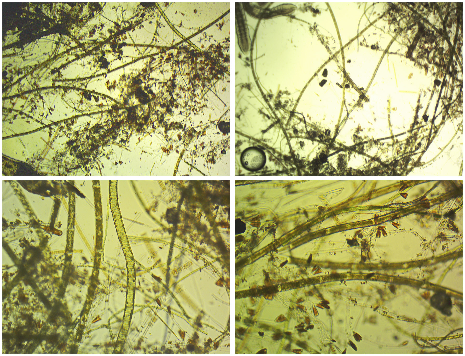
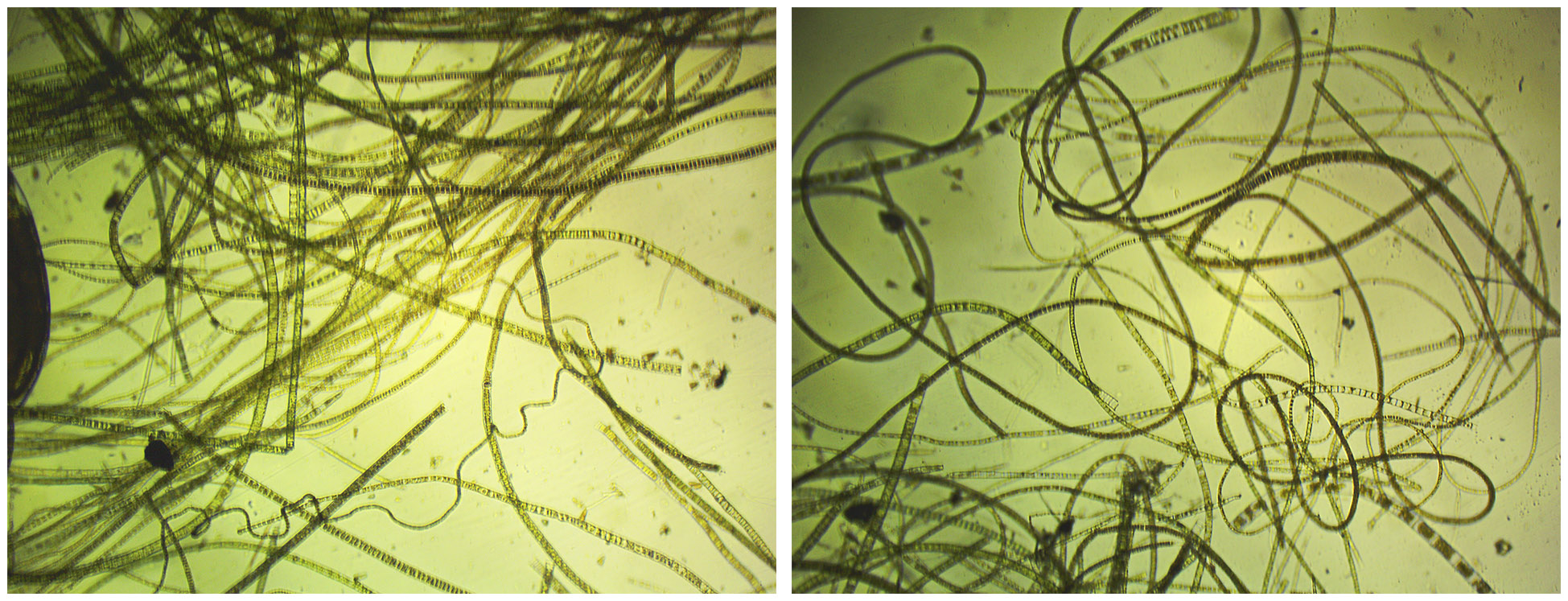
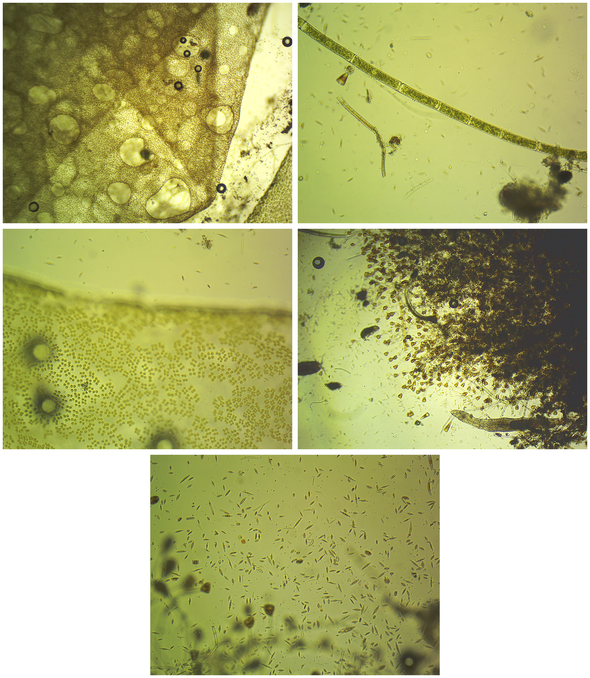
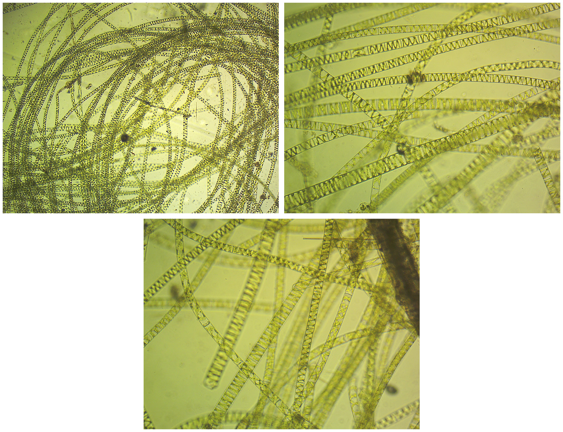
3. Phytobenthos and microplastics. И. Of the 187 samples collected using the stone-unit method to study the production characteristics and structure of the phytobenthos in the coastal zone, 108 samples were examined under a microscope in a living state (including about 10 qualitative samples taken with a hand net, and 1 sample – a wash from several stones). Samples of macrophytobenthos, typically collected in the shoreline zone where Ulothrix zonata almost always dominates, were preserved (and frozen) without live microscopic examination. In such cases, every third sample was examined microscopically. As in previous years, the focus was on identifying sites and depth ranges within the coastal zone where alien algae of the genus Spirogyra and other species were found. It is well known that the occurrence of abundant Spirogyra filaments in June generally suggests their year-round vegetation in that locality. Filaments of Spirogyra representing two morphotypes were recorded, with varying degrees of abundance, at the following stations (Figs. 1–4, photographs by O.A. Timoshkin): Nerpinarium (Listvyanka, at depths of 0.7–1.7 and 2 m); the settlement of Bolshoye Goloustnoye (0.5–4 m); Ayaya Bay (0.5–2.5 m); Shamanka Bay; the settlements of Babushkin and Kultuk (at 1.5 m in all cases); and offshore from Slyudyanka (depths of 0.5–1.5 m). Additionally, shoreline accumulations of Spirogyra were observed in Senogda Bay and off the settlement of Zarechny (near Severobaikalsk). It is worth emphasizing that the riverine morphotype of Spirogyra typically dominated at depths of around 0.5 m, while, in contrast, Spirogyra morphotype No. 2 was encountered at all the aforementioned stations at depths exceeding 1.5 m. Various types of microplastic (MP) particles were observed in micrographs with algae in approximately 30 samples taken at the following 15 stations: Station and Korchma (Bolshiye Koty), Bolshoye Goloustnoye, Aya, Sakhyurta, Khuzhir, Shamanka, Bolshoy Solontsovy, Elokhin, Frolikha, Maksimikha, Baikalsk (opposite the Baikal Pulp and Paper Mill), Slyudyanka, Kultuk, and Sharyzhalgay. As a rule, MP was detected in fouling communities at depths of about 0.5 m.
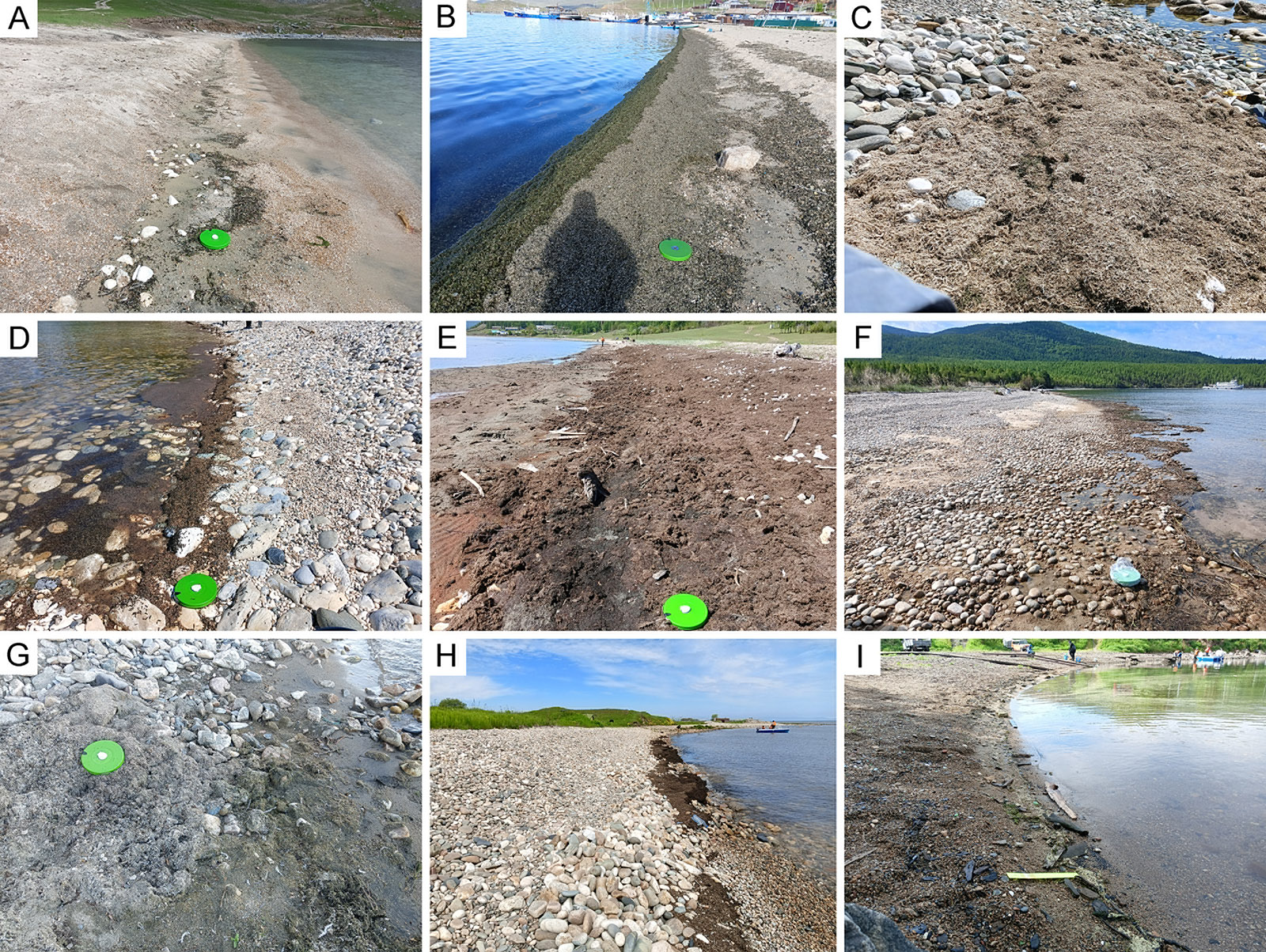
Coastal detritus accumulations (CDA, fig. 5). Sampling and preliminary report: T.M. Alekseeva, R.S. Krivorotkin; scientific supervision: A.V. Nepokrytykh (Cand. Sci., Biol.), O.A. Timoshkin (Dr. Sci., Biol.). CDA were detected at 10 out of the 29 stations studied. The largest accumulations were found in Severnaya Bay (Bolshoy Ushkany Island), offshore from the settlements of Sakhyurta and Zarechnoye. CDA samples were collected for studies of their composition and quantitative characteristics under laboratory conditions.
Biodiversity of invertebrates (responsible - T.M. Alekseeva and R.S. Krivorotkin):): studies on the composition of the faunas of microturbellarians, ostracods, harpacticoids, and bathynellids of Lake Baikal were carried out. For morphological and molecular biological analysis of these groups, 72 samples were collected using scrapers, dredges, trawls, and bottom grabs at depths ranging from 0.2 m to 350 m. Representatives of new endemic species to Lake Baikal were found from the genera Cytherissa и Candona (Ostracoda), Riedelella and Coulterella (Kalyptorhynchia), as well as rare and poorly studied species of all four groups of meiobenthic animals.
Water quality assessment using sanitary-microbiological indices (Cand. Sci. (Biol.) V.V. Malnik, responsible executor).
Samples were collected at 24 sites along the shoreline of the entire Lake Baikal (across all three basins) at predetermined stations. A total of 126 samples were taken, comprising 10 river samples, 62 surface water samples from Baikal, 29 near‑bottom Baikal samples, and 25 interstitial samplesAccording to the established standards, the concentrations of coliform bacteria and fecal enterococci in waters used for recreational purposes should not exceed 100 and 10 CFU/100 mL, respectively (SanPiN 1.2.3685-21). According to the results of the study, 5 out of 10 river samples (50% here and below – proportion of the total number), 12 out of 62 surface Baikal samples (about 19%), and 2 out of 29 bottom Baikal samples (7%) did not comply with the established standards. Significant exceedances of the standards for E. coli and enterococci were recorded at the following locations: 1) the Pokhabikha River – surface sample (50 m below the wastewater discharge pipe): 3,770 and 5,000 CFU/100 mL, respectively; 2) the Pokhabikha River – surface sample (estuary, approximately 500 m downstream from the discharge pipe): 1,160 and 850 CFU/100 mL, respectively; 3) Lake Baikal, near Slyudyanka, 10 m from the mouth of the Pokhabikha River – bottom sample: 1,260 and 700 CFU/100 mL, respectively; 4) the settlement of Sakhyurta – surface sample (1 m from the shoreline): 110 and 195 CFU/100 mL, respectively; 5) the settlement of Sakhyurta – surface sample (1 m from the shoreline): 27 and 58 CFU/100 mL, respectively; 6) the settlement of Uzury – surface sample (1 m from the shoreline): 438 and 404 CFU/100 mL, respectively; 7) the settlement of Kultuk – surface sample (1 m from the shoreline): 75 and 184 CFU/100 mL, respectively; 8) Lake Baikal near Slyudyanka, opposite the mouth of the Pokhabikha River (95 and 246 CFU/100 mL) and to the left of the mouth (21 and 100 CFU/100 mL), respectively. Minor exceedances in enterococci counts were recorded 10 m above the discharge pipe in the Pokhabikha River, at the mouths of the Bolshaya and Malaya Cheremshanka rivers, as well as in surface water opposite the post office at the settlement of Listvyanka, in Baikal surface water 1 m from the shoreline at the settlement of Khuzhir, in bottom water near the settlement of Kultuk, in Baikal surface water near the settlement of Zarechny, and in Senogda Bay (E. coli also slightly exceeded the standard in both surface samples).
In addition, surface water samples were collected from the Tyya River (4 samples), as well as one surface water sample from Lake Baikal at the mouth of the Tyya River, for DNA extraction to identify the source of pollution in these rivers (using molecular genetic markers).
The analysis of the material collected during the expedition is ongoing in the specialized laboratories of the Institute, and the final results will be presented in the report on the state assignment.
Data storage and transfer:
All collected material is stored in the laboratories of Aquatic Invertebrate Biology, Microbiology, Hydrochemistry, and Atmospheric Chemistry at LIN SB RAS; most of the material is currently being processed.